

(click link to jump to section)
• Plan Bay Area • SamTrans New Service Plan • El Camino Real Bus Rapid Transit • Caltrain Modernization • Transbay Transit Center and Caltrain Downtown Extension
Plan Bay Area
Plan Bay Area is a comprehensive initiative linking our region’s transportation, housing, and employment needs over the next 25 years. The Plan grew out of the California Sustainable Communities and Climate Protection Act of 2008 (SB 375).
Since transportation is the largest contributor to GHG emissions in the state, SB 375 requires each of the state’s 18 metropolitan regions, including the nine county Bay Area, to create a Sustainable Communities Strategy to reduce GHG emissions from cars and light trucks. In the Bay Area, the targets are a 7% per capita emissions reduction by 2020 and a 15% per capita reduction by 2035. To comply with SB 375, each region’s Sustainable Communities Strategy must also create housing plans to accommodate 100% of the projected population growth by income level between now and 2040.
Plan Bay Area, which allocates $292 billion to fund transportation-related projects over the next 25 years, is a collaboration of the Metropolitan Transportation Commission (MTC), the Association of Bay Area Governments (ABAG), and other regional government agencies. The final plan was adopted in July 2013.
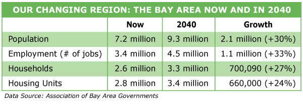
Housing and Job Growth
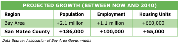
As Plan Bay Area emphasizes utilizing the existing transportation network (including Caltrain and BART) to better connect homes and jobs, the majority of housing growth (77%) and job growth (75%) is projected to be in the counties serviced by this network: San Francisco, San Mateo, Santa Clara, and Alameda.
The cities of San Jose, San Francisco, and Oakland are the three main regional centers that will absorb much of this growth. Regional corridors, like the El Camino Real/Grand Boulevard in San Mateo County will also see significant housing and job growth.
Focused Growth
Plan Bay Area focuses growth heavily in Priority Development Areas (PDAs). PDAs are transit-oriented, infill development areas in existing communities, where there can be concentrated housing and employment growth. Under Plan Bay Area, PDAs are projected to accommodate 78% of the region’s new housing and 62% of the new jobs.
Priority Conservation Areas (PCAs) are regional open spaces where there is a need for long-term protection, but due to growth, there may be pressure for development. By focusing growth in the PDAs, the goal is to preserve PCAs for open space recreational areas and agricultural lands.
Investments
The funding for Plan Bay Area comes from a combination of local (53%), state (15%), regional (15%) and federal (11%) monies. Since the Bay Area has an older, more extensive transit network than other metropolitan areas in the state, the main investment strategy of Plan Bay Area is “fix it first,” with the focus on maintaining and increasing the efficiency of our existing transit and road networks. Eighty-seven percent of total funds are for maintenance of the existing system, including nearly $3 billion for replacing BART and Caltrain’s fleets over the next decade.
Other strategies include
- Supporting focused growth by targeting transportation investments in PDAs that support transit-oriented development.
- Building Next Generation Transit. This includes the BART extension to San Jose and the Oakland Airport Connector, the Transbay Transit Center, Caltrain Electrification, and the Caltrain Downtown Extension.
- Boosting freeway and transit efficiency. $3.9 billion is earmarked for ramp metering, cameras, message signs and speed sensors; arterial operations including traffic signal coordination, transit-priority timing, emergency/incident clearance; incident management; improved traffic clearing after incidents; traveler Info/511 for traffic, transit, parking data for trip-planning, and real-time information; operation & maintenance.
- Protecting the Climate. Investments are earmarked for commuter benefit ordinances and expanding car sharing programs ($13 million), incentives for vanpool programs ($6 million), clean vehicle feebate program and smart driving strategy public education campaign ($160 million), incentives for purchasing plug-ins and electric vehicles ($120 million), and installation of more Electric Vehicle charging stations ($80 million).
One Bay Area Grant Program
One Bay Area Grants (OBAG) provide $320 million over the next four years ($14.6 billion over entire plan) to support areas that focus housing growth in PDAs and that make efforts to create affordable housing. To be eligible for OBAG funding, a city must meet two criteria: 1) have a Complete Streets resolution. 2) have a General Plan Housing Element adopted and certified by the State Department of Housing and Community Development (HCD) to be RHNA compliant (for more on RHNA, see our Housing Indicator).
San Mateo County PDAs
- El Camino Real Corridor
- Brisbane (with City and County of San Francisco): San Francisco/San Mateo Bi-County Area
- Daly City: Bayshore Neighborhood and Mission BART Corridor
- East Palo Alto: Ravenswood Business District and 4 Corners
- Menlo Park: El Camino Real Corridor & Downtown
- Millbrae: Transit Station Area
- Redwood City: Downtown
- San Bruno: Transit Corridors
- San Carlos: Railroad Corridor
- San Mateo: Downtown, El Camino Real, and Rail Corridor
- South San Francisco: Downtown
For a map of PDA areas in the county, click here.
San Mateo County PCAs
- Pacifica Conservation Area: this area is located south of Mussel Rock to McNee Ranch State Park.
- Montara Mountain Complex: located 7 miles south of San Francisco, this scenic area near Highway 1 has over 200 acres of land in agricultural production.
- Gateway to San Mateo County Coast: this area of unprotected open space and agricultural lands is located along Highway 92.
- San Francisco Bay Trail and the Bay Area Ridge Trail: The San Francisco Bay Trail runs along the shoreline and the Bay Area Ridge Trail runs along the ridgelines overlooking the Bay.
- Lobitos Ridge Corridor: this area is located south of Half Moon Bay.
- Upper San Gregorio Creek Headwaters: this area includes the ridge lands and valleys that run south of Portola Valley.
- San Francisco Watershed Lands to Wilder Ranch: located in the Santa Cruz Mountains in San Mateo County, this area contains significant stands of old-growth redwood and Douglas-fir forests.
To read more about the PCAs in San Mateo County and see the PCAs for the entire Bay Area,click here.
SamTrans New Service Plan
In January 2014, SamTrans launched their new long-range Service Plan. The plan aims to increase bus ridership and revenues – with no additional operating costs – by providing more reliable, frequent, and convenient service.
Key to the plan is improving service in those places in the county with the highest concentrations of residents, jobs, and transit riders. These areas include the El Camino Real Corridor where 55% of weekday ridership takes place. In addition, Daly City, South San Francisco, San Bruno, parts of San Mateo, Redwood City, and East Palo Alto all have high concentrations of ridership. In these transit-supportive areas, frequency of bus service has been improved from 30 minutes to every 15 minutes.
Other steps taken to streamline operations include consolidating some overlapping routes and discontinuing costly routes that had low ridership. In addition, SamTrans is launching two pilot projects in Pacifica and San Carlos to test flexible demand response service.
To learn more, click here.
El Camino Real Bus Rapid Transit
SamTrans is launching a Phasing Study of a Bus Rapid Transit (BRT) system along the El Camino Real Corridor from Daly City to Palo Alto. BRT, which is sometimes described as a “surface subway,” attempts to combine the speed and amenities of light rail with the lower cost and smaller infrastructure needs of a bus system. Currently, BRT systems are in operation in 166 cities worldwide . Features of BRT can include limited or skip stops; bus priority at traffic signals, enhanced stops with more passenger amenities, off-board fare collection, and even dedicated bus lanes.
El Camino Real was chosen for the BRT study as it is heavily used with a daily average of 29,000 vehicle trips and 12,000 bus riders. With forecasted population and employment growth and plans for increased housing along El Camino Real, congestion is projected to increase in this area. A BRT system could help relieve this congestion by providing enhanced bus service at faster speeds and with shorter travel times. The Phasing Study will run through mid-2015. It will look at low-cost operational improvements as well as more capital-intensive improvements.
For more information, click here.
Caltrain Modernization
The Caltrain Modernization project aims to upgrade the capacity, performance, and safety of the Caltrain system.
Phase One of the project is the installation of a federally-mandated advance signal system that will help monitor and control train movements in the event of human error. This will improve safety in the corridor by eliminating the risk of train-to-train collisions and reducing the risk of derailments. Phase one is in process now with the system expected to be operational by 2015.
Phase Two of Caltrain Modernization is the Peninsula Corridor Electrification Project (PCEP), which involves electrification of the corridor and the purchase of electrified trains to replace the diesel fleet. Electrification of the corridor will create the necessary infrastructure to meet the needs of future combined track use by Caltrain and High Speed Rail. It will also reduce Caltrain’s environmental impact by replacing highly-polluting diesel trains with cleaner and quieter electric trains. Electric trains start and stop faster than diesel trains, thereby allowing for increased service (from 5 trains per hour per direction to 6) and faster travel. Phase two is currently in environmental review. Construction is expected to run from 2016-2018, with the system operational in 2019. The $1.5 billion cost for phase two is funded through a combination of local, regional, and federal funds to match $705 million in high speed rail bond revenues.
For more information, click here.
Transbay Transit Center and Caltrain Downtown Extension
The San Francisco Transbay Transit Center (TTC) is envisioned as the Grand Central Station of the West. This $4.1 billion project would replace the current Transbay Terminal at First and Mission with a new multi-modal terminal connecting Caltrain to both San Francisco and East Bay transit providers. The TTC is expected to be completed in late 2016, with bus operations starting in August 2017. Surrounding the TTC will be a transit-friendly neighborhood with 3,000 homes (35% of which will be affordable) and mixed-use commercial development.
Caltrain Downtown Extension (DTX) would extend Caltrain from the 4th and King Street station 1.3 miles underground to the Transit Center. DTX was scheduled for completion in 2019, but work is on hold due to lack of funding.Phase one of the project (the TTC) has an estimated cost of $1.6 billion, while phase two (DTX) has an estimated price tag of $2.5 billion.